TOURISM AND SPORT
Bikes, Scooters
1. Horská Kvilda – Zhůří – Zlatá Studna – Horská Kvilda
easy trip of about 15 km including detours to Zlatá Studna and Huťská mountain (if excluded, the trip is shorter by 4 km)
2. Horská Kvilda – Filipova Huť – Kvilda – Horská Kvilda
easy trip of 15 km
3. Horská Kvilda – Filipova Huť – springs of the Vltava – Kvilda – Horská Kvilda
trip of medium difficulty - 27 km
3a. Horská Kvilda – Filipova Huť – Černá hora – Bučina – Kvilda – Horská Kvilda
trip of medium difficulty - 30 km, including detour to the spring of the Vltava (1 km)
4. Horská Kvilda – Filipova Huť – Modrava – Březník – springs of the Vltava – Kvilda – Horská Kvilda
trip of medium difficulty - 35 km
5. Horská Kvilda – Kvilda – Bučina – Knížecí Pláně – Borová Lada – Nové Hutě – Horská Kvilda
trip of medium difficulty - 35 km
6. Horská Kvilda – Kvilda – springs of the Vltava – Bučina – Kvilda – Horská Kvilda
trip of medium difficulty - 25 km
7. Horská Kvilda – Modrava – Tříjezerní slať (Three Lake Fen) – Poledník – floating canal – Antýgl – Horská Kvilda
difficult day-long trip of 40 km, the last section mounting through the valley of the Hamerský stream to Horská Kvilda is not a cycling route and the bike must be wheeled; it is an extremely attractive route with many interesting destinations for bikers in good physical condition
8. Horská Kvilda – Modrava – Tříjezerní slať (Three Lake Fen) – floating canal – Horská Kvilda
trip of medium difficulty - shortened version of the trip No. 7 above (22 km), leaving out Poledník mountain; nice trip with many places of interest; the last section is the same as in the trip No. 7
Hiking
1. Horská Kvilda – Antýgl – Turner Cottage and back
easy trip of 15 km, suitable for prams
By the blue-marked tourist path to Antýgl along the Hamerský stream and from here by the Povydří instructive path (red mark) to the Turner Cottage. The path is designed exclusively for walking tourists.
2. Horská Kvilda – Antýgl – Turner Cottage – Zhůří – Horská Kvilda
trip of medium difficulty - 16 km long route with four-kilometre mounting to Zhůří
By the blue-marked tourist path to Antýgl along the Hamerský stream and from here by the Povydří instructive path (red mark) to the Turner Cottage (similarly to the trip No. 1 above). Then continue by the forest path uphill to Zhůří along the yellow-marked tourist path. From Zhůří by the green-marked path copying the ancient Golden Path.
3. Walk to Výhledy
4 km long, suitable for children (and prams)
Along the forest road; on the fork in the distance of 800 m take the right road.
4. Horská Kvilda – Antýgl – Filipova Huť – Horská Kvilda
14 km long easy trip
By the blue-marked tourist path in direction of Antýgl; right ahead of Antýgl follow the yellow-marked tourist path to Filipova Huť. From here to Horská Kvilda by the forest asphalt road or by the green-marked tourist path (former Golden Path).
5. Horská Kvilda – Zhůří (memorial to victims of an air crush) – Zlatá Studna – Horská Kvilda
14 km long easy trip
By the green-marked tourist path (former Golden Path) by the forest trail to Zhůří (last section by the road). From here by the yellow-marked tourist path to Zlatá Studna and by the blue-marked tourist path back to Horská Kvilda.
7. Horská Kvilda – Filipova Huť – Horská Kvilda
10–11 km long easy trip
Along the forest asphalt road, in the beginning by the green-marked tourist path (which turns after a short distance to the left) to Korýtko - Filipova Huť. Here you can follow past Horní Antýgl (after 1,3 km of the asphalt road turn right by the forest road without marking). To get back take the forest path copying the ancient Golden Path (green marking).
8. Horská Kvilda – Kvilda – Filipova Huť – Horská Kvilda
15–16 km long easy trip
By the road (yellow marking) to Kvilda. Here take detour to Jezerní peat-bog. In Kvilda continue by the yellow-marked tourist path to Filipova Huť - Korýtko. Here take the green-marked tourist path to Horská Kvilda (the way back partially goes together with the yellow-marked tourist path).
9. Horská Kvilda – Antýgl – Rokyta – Vchynice-Tetov – Modrava – Filipova Huť – Horská Kvilda
18 km, trip of medium difficulty
By the blue-marked tourist path along the Hamerský stream to Antýgl, then by the red-marked tourist path to Rokyta, Vchynice-Tetov and Modrava - first 300 m by the road, then along the path. In Modrava continue by the green-marked tourist path to Horská Kvilda past Filipova Huť - Korýtko. The route partially leads by the road. In Korýtko the green-marked path joins the former Golden Path.
10. Walk to Hamerské houses
4 km long trip, suitable for children (and prams)
Walk through Horská Kvilda to the pasture of the mountainous cattle, continue to the Hamerský stream ("sejpy"), and to the hotel Rankl (children playground); the statue of Rankl Sepp opposite to the hotel.
11. Horská Kvilda – Zlatá Studna – Popelná – Obří hrad (Giant Castle) – Kašperské Hory – Kozí Hřbety – Zhůří – Horská Kvilda
day-long difficult trip, 32 km
Along the blue-marked tourist path to Zlatá Studna, then by the red-marked tourist path along the Losenice to the Celtic oppidum Giant Castle, from here to Kašperské Hory. The way back leads along the green-marked tourist path to Kozí Hřbety, Zhůří and Horská Kvilda.
The above mentioned round trip can be reduced to two shorter ones:
1. Horská Kvilda – Zlatá Studna – Obří hrad (Gian Castle) and back (along the blue-marked tourist path to Zlatá Studna and then along the red-marked tourist path)
21 km, trip of medium difficulty
2. Horská Kvilda – Zhůří (memorial to air crush) – Kozí Hřbety and back. The trip follows the green-marked tourist path.
20 km, trip of medium difficulty
12. Mounting to Antýgl
7 km, route with no marking, information to be get at the Information Centre of Horská Kvilda
Cross-Country Skiing Hints
1. Horská Kvilda – Zlatá Studna – Zhůří – Horská Kvilda
15 km, easy trip. Optional extension with detours to Zadov and Churáňov.
2. Horská Kvilda – Zlatá Studna – Pláně (Plains) – Nové Hutě – Borová Lada – Bučina –Kvilda – Horská Kvilda
33 km, medium difficulty
3. Horská Kvilda – Kvilda and back
10 km, easy trip with moderate super-elevation.
4. Horská Kvilda – Kvilda – Filipova Huť – Horská Kvilda
12,5 km, easy trip.
5. Horská Kvilda – Antýgl – Turner Cottage and back
15 km, easy trip.
6. Horská Kvilda – Filipova Huť – Modrava – Březník – Černá hora – springs of the Vltava – Kvilda – Horská Kvilda
36 km, difficult trip.
7. Horská Kvilda – Kvilda – springs of the Vltava – Stráž – Bučina – Kvilda – Horská Kvilda
25 km, difficult trip.
8. Round tracks in the meadows of Horská Kvilda
Several-kilometre tracks with moderate super-elevation.
9. Horská Kvilda – Filipova Huť – Modrava – Modrava bridge – Ptačí reservoir –Filipova Huť – Horská Kvilda
28km, difficult trip.
Up-to-date information about condition of cross-country skiing tracks
Downhill Skiing
Other Activities
1. Čeněk's Sawmill
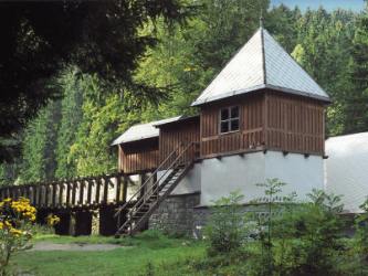
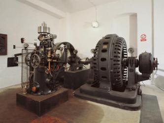
The small hydro power station Vydra is situated close to the confluence of the Vydra and the Křemelná rivers between the villages of Rejštejn and Srní in Sušice district. The Vydra has a steep waterfall at its upper stream and enough water for the most part of the year. The construction of the power station was initiated in 1937 and in 1939 it came into operation as a run-of-river power station. Its full operation started after completion of the accumulation reservoir in January 1942. Waters of the historical Vchynicko-tetovský Canal is carried away by an underground feeder into the accumulation reservoir of 67 000 cubic metres nearby the former settlement of Sedlo. The machine room contains two turbo-sets composed of a horizontal Francis turbine with the output of 3,2 MW and a three-phase generator.
Both turbines went through modernization in 2005 and 2006, two new pump aggregates of the regulation unit were installed, the generators of both turbo-sets were rewound and a new control system of the power station was installed. Since January 2007 the run-of-river operation was transformed into the operation in peak-hours. Outside these peak-hours the power station supplies electricity into the grid only if a sufficient water inflow into the accumulation reservoir Sedlo allows it. The building of Vydra power station houses an exposition relating to the Šumava water power stations accessible to public.
Exposition of the Šumava energy
open June - September
Tel: +420 387 001 111, +420 840 840 840
2. Permanent exposition on history of Kvilda and Bučina
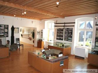
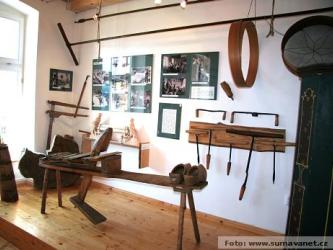
The exposition provides all information and artefacts relating to the way of life and work of our ancestors. The exposition is divided into several parts characterizing history of the region. Archival documents are presented by copies (e.g. deeds from the 14th century or a map of the Kašperské Hory branch of Golden Path from 1736).
The exposition is installed on the first floor of the Municipal Office in Kvilda, in the building of former school. On the walls of the stairway there are maps of the cadastral area, period photographs and picture postcards documenting the area in vicinity of Horská Kvilda. The exhibits were borrowed from the Museum of Kvilda (Gefilder Heimatstube), Municipal Office of Mauth, from the Czech museums in Sušice, Kašperské Hory, Vimperk, Netolice, from the National District Archives in Prachatice and Klatovy and from private collections.
Tel : +420 723 983 864
3. Kašperk Castle
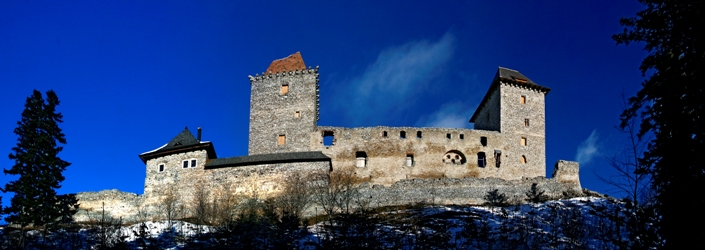
The highest elevated castle in Bohemia (886 m) was founded in 1356 by the Czech King and Roman Emperor Charles IV to protect the gold-bearing region and the trade route as well as to guard the country borderline with Bavaria. The castle core is formed by two residential towers of the same height and a palace. The castle has never been conquered. The romantic structure amidst the Šumava forests attracts visitors from near and far.
Tel: +420 376 582 324
4. Sušice Museum
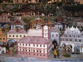
The Museum of Šumava is situated right in centre of the town in Svoboda square, in the Renaissance house with Gothic foundations from the late 15th century. The Museum was founded in 1880 already by local teacher Josef Holík as the first museum in the whole region of the Šumava mountains. Its collections were first placed at the Town Hall and later moved to the present premises. The present building of the Museum was housing deanery in the period from 1775 to 1936, afterwards the premises were handed over to the town museum. The exhibits include various objects related to history of the town and its neighbourhoods. There is an exhibition focused on the Šumava glass-making, a collection documenting the history of matches production in Sušice (one of the most significant in the whole Europe), Sušice pewter treasure, Capuchin library, or unique Bruno Schreiber's glass collection. A significant attraction is the Sušice mechanical crib with copies of important town buildings, showing the ancient and traditional Šumava crafts. It is one of the largest mechanical cribs in the Czech Republic and was made in only ten months in 2004. It is 5 metres long, 3,5 metres deep and 2,8 metres high. There are about 150 movable and 150 fixed figures, 35 buildings, and the new ones are continuously added. The crib has been accessible to public since the end of 2004.
Tel: +420 376 528 850
5. Museum in Kašperské Hory
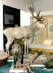
The museum is situated in the lower part of the town square. It displays permanent expositions relating to gold mining, glass-making or forestry. We can admire here a collection of Late Gothic sculptures from the turn of the 15th and 16th centuries or paintings and pictures with the Šumava motives. There are exhibits related to gold mining, to the life of the Šumava people as well as samples of the local folk art.
Tel: +420 376 582 226
6. Cable Climbing Centre Proud in Zadov
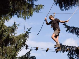
The outdoor climbing centre offers three programs and round tours varying according to the level of experience:
Low-placed cables – program suitable for smaller children
Intermediate climber – climbing in the height of 8 metres
Advanced climber – superb adventure in the real height
Tel: +420 605 215 396
7. Karoli Badepark
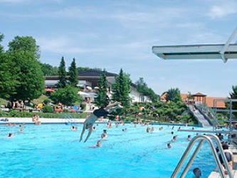
Extraordinary water park in the German town of Waldkirchen right behind the border. Pools, saunas, water world, slides, switch-backs.
Tel: +49(8581)202–0
8. Open-air Museum of Finsterau
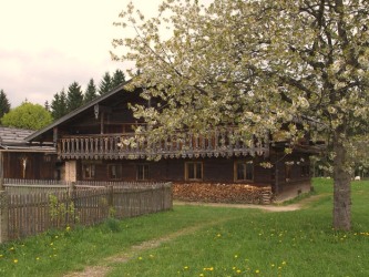
At the altitude of 1000 metres above see level, hidden amidst the forests and mountains of the National Park and close by the Czech border, the history has found its reserve in form of the Open-air Museum of Finsterau. There are rustic houses, farmsteads, a smithery or a wayside inn - the history materializing in the open air.
Tel: +49(8557)9606–0
9. Natural trail in the treetops, observation tower by Neuschenau
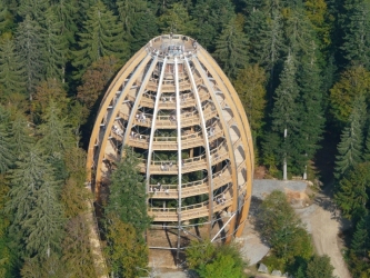
The worldwide longest trail in the treetops has 1300 m in length and enables walking in the height of 8 to 25 metres above the ground. The visitors walk through the intact nature of the treetops and may admire unique views from this unusual perspective. The trail is situated in the Bavarian National Park and the entrance thereto to is placed by the car park and the free range. The entrance tower is equipped with an elevator offering comfortable and free access to seniors, wheelchair users and parents with prams. On their way along the mostly wooden structure carefully planted into the mixed forest the visitors may relish a real and pure natural experience, augmented with various didactic, orientation-sensory elements alongside the whole trail. They will learn a lot about the landscape and its varying life forms from a completely new perspective. At the end of the 1300 m long footpath the visitors reach a platform of a 44 m high observation tower offering fantastic and almost limitless view.
Tel: +42(0776)114566
10. Zoo-Park
In vicinity of the town of Neuschenau, in the National Park of Bavarian Forest, there is a beautiful zoological park, where we can observe diverse wildlife species in their natural environment.
Tel: +42(08552)9600–0


